Data types
ThoughtSpot supports the common data types.
Before you import data, compare the data types you want to load with these supported data types. Then, convert your data before loading it. Typically, you would export the data, transform it to meet these type rules, and then load the data. This is known as an extract-transform-load process.
Supported data types
The tables you create to receive the data must have the same number of columns and data types as the data you will be loading. Choose a data type for each column from the list of supported data types:
| Data | Supported data types | Details |
|---|---|---|
Character |
|
Specify the maximum number of characters, as in |
Floating point |
|
We recommend that you use |
Boolean |
|
Can be |
Integer |
|
|
Date or time |
|
|
There is a 64MB limitation on the number of characters for VARCHAR.
If you have any VARCHAR data that exceeds this limit, the entire load will fail.
|
Geographical data types
ThoughtSpot supports geographical data.
How to import geographical data
Import your geographical data as text values.
This ensures that the data defaults to the correct configuration, where the data type is VARCHAR.
You can use DOUBLE or VARCHAR for latitude and longitude data.
See the following example:
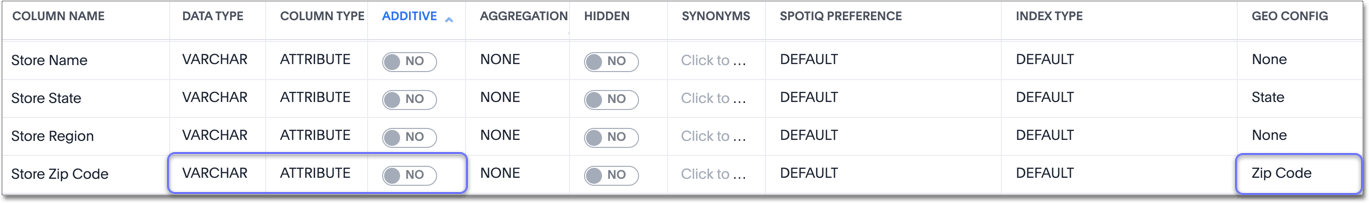
In the above example, the zipcodes were imported as text values.
By default, the data type is VARCHAR, the column type is attribute, and additive is no.
You must specify the geo config for your data yourself.
ThoughtSpot does not specify geo config automatically.
If you import zipcodes as numeric values, the column type defaults to measure.
In ThoughtSpot, a measure is a numeric value that you can you use in mathematical formulas.
If you import your geographical data as numeric values, you must change the column type to attribute and specify additive as no.
Latitude and longitude
For latitude and longitude, you can use either VARCHAR or DOUBLE.
Note that your latitude and longitude data must be in the form of positive and negative numbers, and not in the form of degrees.
North of the Equator, latitude values are positive, and south of the Equator, latitude values are negative.
East of the Prime Meridian, longitude values are positive, and West of the Prime Meridian, longitude values are negative.
Designate your geographical data in ThoughtSpot
After loading the data, designate it as a geographical data type when you Edit the system-wide data model. Wherever abbreviations or codes are used, they are the same as what the USPS (United States Postal Service) recognizes.
These data types can be designated as geographical data, which enables them to be visualized using the Geo chart types:
-
Countries, for example:
-
United States
-
long name: United States -
name_sort: United States of America -
abbreviation: U.S.A. -
adm0_a3: USA -
adm0_a3_is: USA -
adm0_a3_us: USA -
admin: United States of America -
brk_a3: USA -
brk_name: United States -
formal_en: United States of America -
iso_a2: US -
iso_a3: USA -
iso_n3: 840
-
-
-
COUNTYfor counties in the United States, for example:-
santa clara county
-
pike county, ohio
-
pike county, OH
-
-
STATE_PROVINCEfor states in the United States, for example:-
name: California -
US Postal Service abbreviation: CA
-
-
LATITUDE, which must be used withLONGITUDE, for example:-
37.421023
-
-1.282911
-
-
LONGITUDE, which must be used withLATITUDE, for example:-
122.142103
-
-103.848865
-
-
ZIP_CODEfor zip codes in the United States, for example:-
po_name: MT MEADOWS AREA -
ZIP: "00012" -
zip2: 12
-
-
Other Sub-nation Regions, which are administrative regions found in countries other than the United States, for example:
-
bremen
-
normandy
-
west midlands
-
| You cannot upload your own custom boundaries. |


